The Intelligence You Need for the Decisions You Make
As Statesboro continues its rapid ascent as a regional hub for manufacturing and industrial development, the margin for error in geospatial data has reached zero. For civil engineers, project managers, and environmental directors in Bulloch County, traditional survey methods are often too slow or too limited to keep pace with modern project timelines. Fair Lifts Survey & Mapping Services represents a fundamental shift in data acquisition. We don't just provide "aerial photos", we deliver high-precision geospatial intelligence that serves as the single source of truth for your project’s most critical decisions.
Our approach addresses the common pain points of regional surveying: costly guesswork, safety risks in active mining or construction sites, and the prohibitive expense of traditional manned aircraft surveys. By utilizing a fleet of Blue UAS certified platforms equipped with survey-grade sensors, we capture millions of metrically precise data points across thousands of acres in a single day. Whether you are conducting a volumetric inventory for a Statesboro aggregate pit or mapping a 100-mile utility corridor, we deliver actionable results that integrate seamlessly into your professional CAD and GIS workflows.
The Security of Blue UAS
In today's security climate, the integrity of your site data is paramount. All Fair Lifts survey systems are Blue UAS Certified, having passed rigorous U.S. Department of Defense cybersecurity and supply chain vetting. For operators of critical infrastructure near Statesboro, including power grids and pipelines, this certification ensures that your sensitive asset data is protected from collection to delivery, mitigating the risks associated with unsecured drone platforms.
Volumetric Surveys: Inventory Precision
For the mining and aggregate sectors of Bulloch County, knowing your inventory "to the last ton" is an operational and financial necessity. Traditional walk-up surveys are not only slow but inherently dangerous for personnel navigating active stockpiles and steep highwalls. Fair Lifts eliminates these risks while increasing measurement accuracy. Our 61MP photogrammetry sensors capture ultra-sharp imagery to create high-density 3D models of your entire site.
We process this data through PIX4Dmatic, the industry standard for large-scale volumetric calculation. This allows us to generate auditable cut/fill reports and stockpile volumes with centimeter-level accuracy. For accounting and sales teams in Statesboro, this means monthly reconciliation is no longer a source of stress. We provide a transparent, measurable record of your assets that can be viewed, analyzed, and shared across your organization within 24 hours of flight, turning your site into a fully measurable asset.
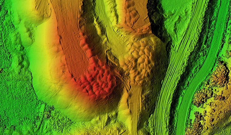
LiDAR Survey Services: Penetrating the Canopy
The South Georgia Coastal Plain is famous for its dense timber canopies, which often make traditional aerial photogrammetry ineffective for mapping the bare ground. Engineering projects in Bulloch County require an unambiguous view of the terrain beneath the trees. This is where Fair Lifts’ LiDAR (Light Detection and Ranging) services are the premier solution. We deploy the Riegl miniVUX-2UAV LiDAR sensor, a system designed for the highest level of vertical accuracy.
LiDAR works by firing millions of laser pulses per second. These pulses penetrate through even the thickest pine and hardwood canopy, bouncing off the ground surface to create a precise "bare earth" Digital Terrain Model (DTM). For Statesboro developers planning new commercial tracts or engineers designing drainage systems, this data is invaluable. Our LiDAR surveys provide better than 1-inch absolute vertical accuracy and a point density of up to 800 points per square foot, revealing hidden topographic features that other methods miss entirely.
Large Scale Surveys & Multi-Aircraft Deployment
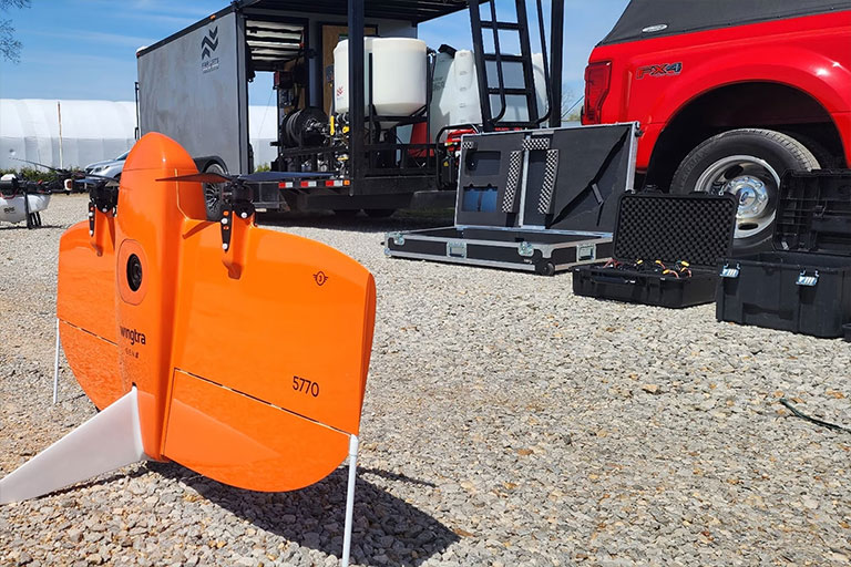
Scale is often the greatest challenge for regional infrastructure projects. Traditional multicopter drones lack the endurance to map massive areas, and manned aircraft are often too expensive for frequent updates. Fair Lifts utilizes the WingtraOne Gen II, a fixed-wing VTOL aircraft that maps 700+ acres in a single flight, more than 10x the area of a quadcopter. For the largest Statesboro projects, such as new industrial parks or vast timber tracts, we deploy multiple aircraft and flight crews simultaneously.
This parallel data collection allows us to map thousands of acres in a single day without sacrificing accuracy. Our integrated PPK (Post-Processed Kinematic) system ensures that every image is geotagged with centimeter precision, significantly reducing or eliminating the need for ground control points. This speeds up the operational timeline and reduces the physical footprint on your site, providing a cohesive, massive dataset ready for GIS analysis or land development planning.
3D Property Mapping & Digital Twins
Transform your projects from acreage to city block with photorealistic 3D digital twins. Traditional maps and blueprints are limited in their ability to convey the spatial context of a complex project. Fair Lifts creates immersive, measurable 3D property models that allow Statesboro stakeholders to visualize, measure, and present with a level of clarity that flat images cannot match.
Using a combination of nadir (top-down) and oblique (angled) imagery, we construct textured 3D meshes and point clouds that serve as an "as-built" record of your site. This is the ultimate tool for construction progress monitoring, architectural shadow studies, and marketing high-value commercial assets. For local developers, a digital twin provides a verifiable record of earthwork and structure placement over time, ensuring that the project remains aligned with the design specifications at every phase of the lifecycle.
Data Accuracy Specs
Horizontal Accuracy
1.0 cm
PPK Enabled Precision
Vertical Accuracy
< 2.5 cm
LiDAR Terrain Data
Ground Resolution
0.7 cm/px
MAP61 Full Frame
Managed Workflow
Your dedicated Statesboro Project Manager oversees the entire workflow, from project scoping and sensor selection to final data processing in Pix4Dmatic. We deliver results in the formats your engineers need: DXF, DWG, LAS, and GeoTIFF.
Request Technical Scoping