
A Professional Framework for Unmanned Success
Welcome to the Fair Lifts Unmanned project intake portal for the Statesboro region. We understand that requesting a quote for large-scale drone services is about more than just checking a price point; it is about initiating a partnership that will impact your yield, your asset integrity, or your environmental compliance. Our project managers are not just sales representatives; they are technical experts stationed right here in Bulloch County, ready to analyze your specific operational goals and provide a data-driven path forward.
The Statesboro business and agricultural community operates on a schedule defined by the seasons and the speed of regional industry. Whether you are a cotton grower managing a critical moisture window or an industrial developer needing rapid volumetric surveys for a new facility on Hwy 301, we respect the urgency of your mission. Our "Consult. Execute. Report." framework is designed to ensure that every engagement is efficient, transparent, and metrically accurate.
The Fair Lifts Statesboro Process
Phase 01: The Regional Consult
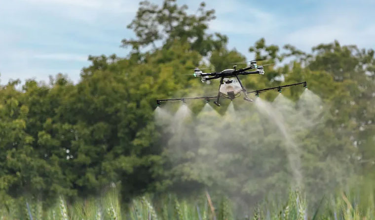
Every successful mission begins with a deep-dive consultation. For our agricultural clients, this means reviewing your field maps, crop types (cotton, peanuts, pecans), and current disease or pest pressures. For our industrial and engineering clients, we analyze your site parameters, accuracy requirements, and data format needs. We don't believe in "one-size-fits-all" solutions. In the South Georgia Coastal Plain, factors like sandy soil drainage, humidity, and local airspace restrictions are critical variables that we account for during the planning stage.
Phase 02: Precision Execution
Once the plan is finalized, our expert flight crews mobilize. Stationed locally in Statesboro, we provide rapid response times that smaller, out-of-town operators cannot match. We deploy the optimal technology for the job, whether that's our heavy-lift XAG P150 application drones or our Blue UAS certified WingtraOne mapping platforms. Our pilots operate under a rigorous safety framework derived from manned aviation standards, ensuring that every acre is treated or mapped with centimeter-level precision while maintaining the highest regard for regional safety protocols.
Phase 03: Intelligence Delivery
The job isn't finished until you have the intelligence you need to make a decision. For agricultural spray jobs, you receive an "As-Applied" map that provides irrefutable proof of coverage and volume. For survey projects, we deliver engineering-grade orthomosaics, 3D models, or LiDAR point clouds in the CAD and GIS formats your team already uses. We close the loop by reviewing these deliverables with you, ensuring that the project met your operational ROI goals.
Regional Mobilization and Commitment
Our commitment to Statesboro extends beyond the flight path. We are invested in the long-term success of the Bulloch County economy. This is why we offer significant multi-year and multi-pass contract discounts for regional growers and industrial partners. By locking in your service early, you guarantee priority scheduling during those narrow summer windows when every other business in the region is fighting for equipment access. We are your year-round technology partner, managing the fleet and the data so you can manage your business.
Frequently Asked Questions
Project Intake Form
Statesboro Regional Office
Ready to Start Your Project?
Discuss your specific goals in Statesboro with a regional expert. We provide rapid mobilization and precision scoping for every regional client.