
Hardware as the Engine of Expertise
At Fair Lifts Unmanned Services, we believe that world-class expertise must be supported by world-class tools. The Statesboro region, with its diverse agricultural landscapes and expanding industrial base, demands technology that is as rugged as it is precise. We do not just "own drones"; we manage a mission-ready technology platform that is updated annually to ensure our clients always benefit from the state-of-the-art. Our fleet is purpose-built to tackle the specific challenges of the South Georgia Coastal Plain from the thick timber canopies of Bulloch County to the sprawling cotton and peanut acreage that defines our local economy.
One of the primary advantages of partnering with Fair Lifts is the removal of capital risk. Drone technology evolves at a staggering pace; hardware purchased today is often obsolete within twenty-four months. By utilizing our services, regional businesses gain access to multi-million dollar technology fleets without the upfront investment, maintenance overhead, or training requirements. We guarantee that your project whether it is a 5,000-acre multispectral survey or a complex infrastructure inspection will be executed with the most efficient, secure, and reliable equipment available globally.
WingtraOne Gen II: The Efficiency Workhorse
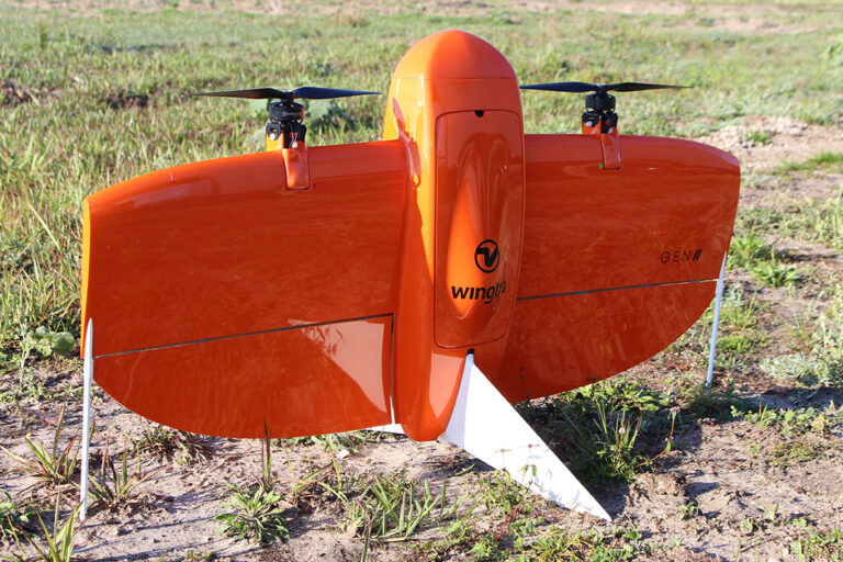
For large-scale surveying and mapping, the WingtraOne Gen II is our flagship workhorse. In a county as vast as Bulloch, efficiency is the difference between a project taking weeks or days. The WingtraOne is a unique fixed-wing platform that features Vertical Take-Off and Landing (VTOL) capability. This allows us to deploy from tight spaces, such as logging roads or small clearings, without the need for a runway, while still maintaining the long-range flight efficiency of a plane. A single Wingtra can map over 700 acres in a single flight more than ten times the area of a traditional multicopter.
This efficiency does not come at the cost of accuracy. The WingtraOne Gen II is equipped with an integrated high-end Post-Processed Kinematic (PPK) GNSS system. By pairing this with our local Emlid base stations, we achieve centimeter-level absolute accuracy without the need for extensive ground control points (GCPs). For Statesboro developers and engineers, this means survey-grade data is delivered faster and more cost-effectively, providing a metrically precise digital twin of your project site.
XAG P150: The Power of Precision Application
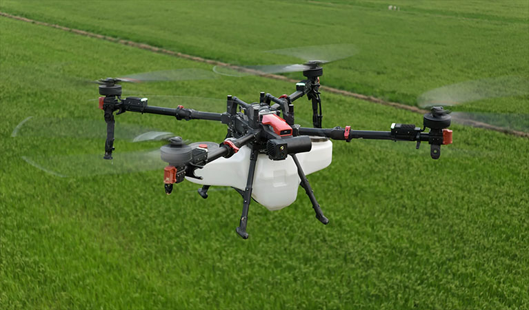
For agricultural and environmental application, we deploy the XAG P150 the world's most advanced heavy-lift application drone. In Statesboro's humid climate, the timing of fungicide and insecticide application is everything. The P150 is built for the grit and demanding duty cycles of South Georgia field work. It features a massive 70L tank and high-capacity centrifugal atomization sprayers. Unlike traditional nozzles that can clog or produce variable droplet sizes, our atomization system creates a uniform, controlled spray that significantly reduces drift and ensures that every drop of chemistry is utilized effectively.
The most critical technical differentiator of the P150 is the downward air vortex created by its powerful rotors. As the drone flies just feet above the crop, this downwash actively "flips" the leaves of the plant, driving the spray into the base of the canopy and onto the undersides of the leaves. For Bulloch County peanut and cotton growers, this 360-degree coverage is essential for stopping diseases like white mold or controlling pests that hide within the thick vegetation. We turn days of dangerous ground-rig spraying into hours of safe, autonomous aerial application.
| UAS Feature | Benefit to Statesboro Farmers |
|---|---|
| Variable Rate Application | Apply chemicals only where needed based on high-resolution map data, reducing input costs. |
| Zero Soil Compaction | Effective spraying immediately after heavy rains when ground rigs would cause permanent soil damage or get stuck. |
| Multispectral Imaging | Identifying "hidden" crop stress and nutrient deficiencies before they are visible to the naked eye. |
| Swarm Technology | Multiple drones working a single field in coordination to cover large regional acreage with maximum efficiency. |
Blue UAS: Security You Can Trust
In an era of heightening cybersecurity concerns, particularly for critical infrastructure and government-adjacent projects, the provenance of your technology matters. Fair Lifts is committed to the security of regional data. Our survey fleet is centered around Blue UAS Certified platforms. This certification, vetted by the U.S. Department of Defense, ensures that our equipment meets the highest standards for cybersecurity, supply chain integrity, and data encryption. When we map a pipeline, a power substation, or a municipal asset in Statesboro, you can be certain that your sensitive geospatial data is protected from collection to delivery. We mitigate the immense risks associated with unsecured consumer-grade drone platforms.
Advanced Processing: Transforming Data into Intelligence
The mission does not end when the drone lands. The final 30% of the value we provide is found in our processing workflow. We utilize the industry-standard PIX4D software suite, including PIX4Dmatic for large-scale industrial photogrammetry and PIX4Dfields for rapid, in-season agricultural analysis. These tools allow our processing specialists to transform terabytes of raw imagery into actionable orthomosaics, 3D point clouds, and multispectral health maps. We deliver results in the CAD, GIS, and farm management formats your professional teams already use, ensuring a seamless integration of aerial intelligence into your existing business operations.
Payload Technology
MAP61 / RGB61
Ultra-high resolution Sony full-frame sensors for razor-sharp mapping and 3D models.
Riegl miniVUX LiDAR
Penetrating GA timber canopy to map the true bare earth terrain with millimeter precision.
MicaSense RedEdge-P
Capturing 5 multispectral bands plus panchromatic for high-res crop health analytics.
Localized Maintenance
Our Statesboro regional office maintains a fully-stocked parts inventory and redundant aircraft. If one system goes down, another is ready to launch.
Request Technical Brief